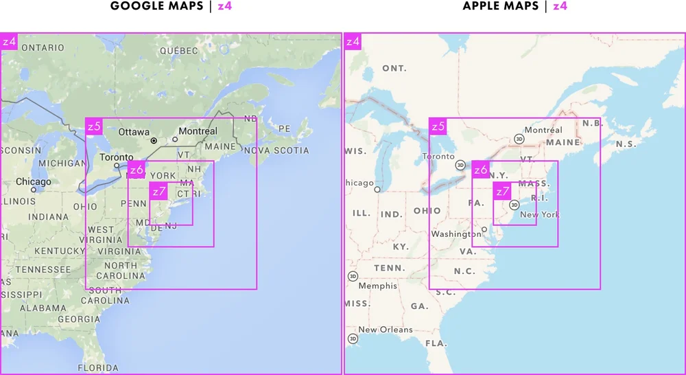
Tippecanoe zoom levels
Tippecanoe CLI syntax:
-z zoom or --maximum-zoom=zoom: Maxzoom: the highest zoom level for which tiles are generated (default 14)
-zg or --maximum-zoom=g: Guess what is probably a reasonable maxzoom based on the spacing of features.
-Z zoom or --minimum-zoom=zoom: Minzoom: the lowest zoom level for which tiles are generated (default 0)
-ae or --extend-zooms-if-still-dropping: Increase the maxzoom if features are still being dropped at that zoom level. The detail and simplification options that ordinarily apply only to the maximum zoom level will apply both to the originally specified maximum zoom and to any levels added beyond that.
-R zoom/x/y or --one-tile=zoom/x/y: Set the minzoom and maxzoom to zoom and produce only the single specified tile at that zoom level.
If you know the precision to which you want your data to be represented, or the map scale of a corresponding printed map, this table shows the approximate precision and scale corresponding to various -z options if you use the default -d detail of 12:
| zoom level | precision (ft) | precision (m) | map scale |
|---|---|---|---|
| -z0 | 32000 ft | 10000 m | 1:320,000,000 |
| -z1 | 16000 ft | 5000 m | 1:160,000,000 |
| -z2 | 8000 ft | 2500 m | 1:80,000,000 |
| -z3 | 4000 ft | 1250 m | 1:40,000,000 |
| -z4 | 2000 ft | 600 m | 1:20,000,000 |
| -z5 | 1000 ft | 300 m | 1:10,000,000 |
| -z6 | 500 ft | 150 m | 1:5,000,000 |
| -z7 | 250 ft | 80 m | 1:2,500,000 |
| -z8 | 125 ft | 40 m | 1:1,250,000 |
| -z9 | 64 ft | 20 m | 1:640,000 |
| -z10 | 32 ft | 10 m | 1:320,000 |
| -z11 | 16 ft | 5 m | 1:160,000 |
| -z12 | 8 ft | 2 m | 1:80,000 |
| -z13 | 4 ft | 1 m | 1:40,000 |
| -z14 | 2 ft | 0.5 m | 1:20,000 |
| -z15 | 1 ft | 0.25 m | 1:10,000 |
| -z16 | 6 in | 15 cm | 1:5000 |
| -z17 | 3 in | 8 cm | 1:2500 |
| -z18 | 1.5 in | 4 cm | 1:1250 |
| -z19 | 0.8 in | 2 cm | 1:600 |
| -z20 | 0.4 in | 1 cm | 1:300 |
| -z21 | 0.2 in | 0.5 cm | 1:150 |
| -z22 | 0.1 in | 0.25 cm | 1:75 |

Комментарии
Отправить комментарий